
10K Course
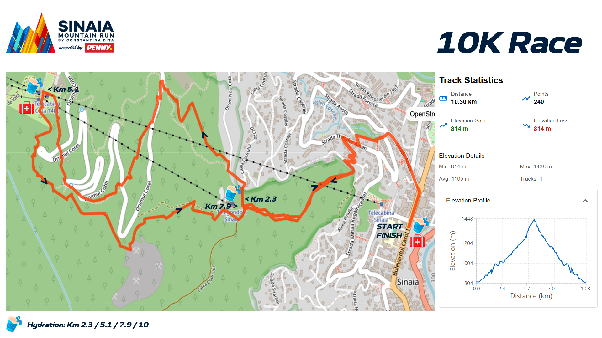
START Primăria Sinaia, Bd Carol – stânga pe str. Aosta – stânga la primul pod, imediat dreapta pe aleea Sion – stânga pe str. Ștefan cel Mare – dreapta pe str Theodor Aman – stânga pe str. Gheorghe Doja – stânga spre poiana Malaxa – se urcă până în Calea Codrului – dreapta – stânga Drumul Cotei -traversare parcare Gondolă – dreapta drum tehnic acces Vama Ursului – stânga marcaj turistic bandă roșie –traversare Drumul Cotei la fosta Cabană 1300 – marcaj bandă roșie – Cota 1400 – stânga pe Pârtia Nouă, coborâre – Gondola 1000 – traversare Calea Codrului – Poiana Malaxa – Str. Gh. Doja – dreapta str. Theodor Aman – stânga str. Ștefan cel Mare – dreapta aleea Sion – dreapta str. Aosta – dreapta Bd. Carol – Primăria Sinaia SOSIRE
21K Course
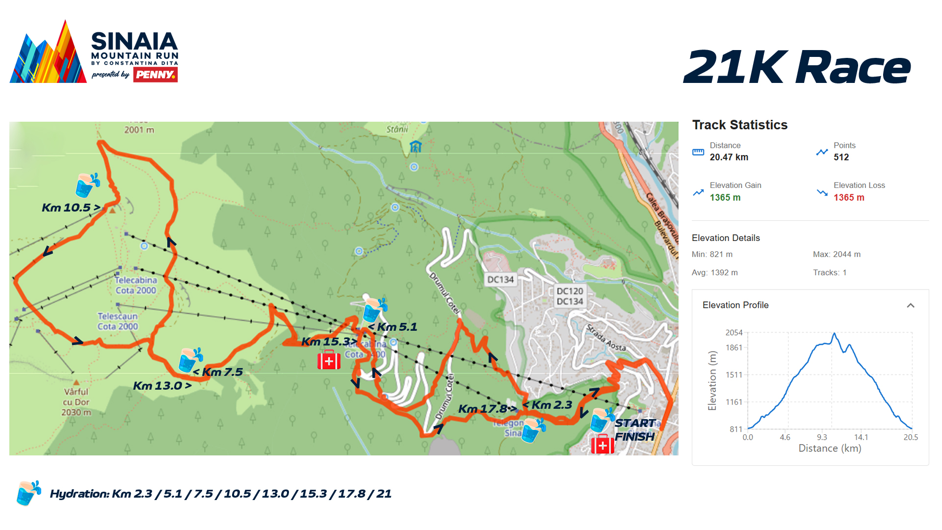
START Primăria Sinaia, Bd Carol – stânga pe str. Aosta – stânga la primul pod, imediat dreapta pe aleea Sion – stânga pe str. Ștefan cel Mare – dreapta pe str Theodor Aman – stânga pe str. Gheorghe Doja – stânga spre poiana Malaxa – se urcă până în Calea Codrului – dreapta – stânga Drumul Cotei -traversare parcare Gondolă – dreapta drum tehnic acces Vama Ursului – stânga marcaj turistic bandă roșie – traversare Drumul Cotei la fosta Cabană 1300 – marcaj bandă roșie – Cota 1400 – Drum de Vară, bandă roșie – deasupra locului “Sub Cetate”, dreapta pe curbă de nivel – stânga, urcare marcaj bandă galbenă spre Vf Furnica – dreapta spre stația superioară telescaun Valea Soarelui – pârtia Lăptici 1 – stânga pârtia Panoramic – Cabana Panoramic – Valea Soarelui – stânga pârtia Variantă – Șaua Vârfului cu Dor – Drum de Vară – Cota 1400 – Pârtia Nouă – Gondola 1000 – traversare Calea Codrului – Poiana Malaxa – Str. Gh. Doja – dreapta str. Theodor Aman – stânga str. Ștefan cel Mare – dreapta aleea Sion – dreapta str. Aosta – dreapta Bd. Carol – Primăria Sinaia SOSIRE
GPX data and map depictions are provided for informational purposes only and represent approximations of the official course. Actual course conditions, route configurations, and terrain may vary.
In the event of any discrepancy, physical course markings, signage, and instructions from local authorities or event organizers shall strictly govern and supersede all digital data. Participants are solely responsible for exercising personal judgment, maintaining situational awareness, and adhering to the marked physical course at all times.
In case of emergency, adverse weather, or other hazards, participants must prioritize safety above all else and immediately contact local emergency authorities and the event organizer, regardless of their location on or off the course.


